|
|
|
|
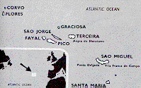
Overview based largely on Encyclopedia Britannica. GeographyThree widely separated groups of islands make up the Azores,
International Airports. Ponta Delgada (PDL) (Sao Miguel), Santa Maria (SMA) (Vila do Porto) and Terceira (TER) (Terceira). Flight about 2 hours from Lisbon (Lisbon is 2 hours from London). TAP Air Portugal operates flights to the Azores and SATA Air Acores runs interconnecting flights between islands. There is a NATO air base on/at Lajes maintained by the USA. Geologically unstable, with many earthquakes and volcanic eruptions. Hot springs can be found. GovernmentAn autonomous region of Portugal with its own government made up of a president and cabinet, regional assembly as the legislature, and its own administration. The Capital of the Azores is Porta Delgada on Sao Miguel, one of the eastern group. EconomyIntensive agriculture produces cereals, vegetables, and fruit including pineapples, bananas, oranges, apricots and grapes for wine production. Many of the islands hillsides are still covered by mixed forests. Exports include hand embroidery, pineapples, canned fish and wine. |
|
Copyright New Atlantis.
|